ICW Railroad

The friendliest place on the web for anyone who enjoys boating.
If you have answers, please help by responding to the unanswered posts.

Roger Long

Senior Member
Joined
Jul 14, 2015
Messages
451
Location
Albany
Vessel Name
Gypsy Star
Vessel Make
Gulf Star 43
I’m curious if other people here are increasingly having experiences like this on the ICW. I’ve gotten lots of confirmation from other social media sites.

You see a vessel coming towards you, show them a bit of port side to confirm a standard meeting and start edging over to the starboard side of the channel. But, they don’t move the other way. They keep coming, pushing you over until your depth sounder makes you back off and stop while they go by with yards and yards of deep water on the proper side of the channel. They’ll give you a nice wave because they think you are stopping for the pass and not because they nearly forced you aground. You may see that they have a burgee identifying them as fans of a fellow who provides GPS tracks delineating, according to his web site, the line of deepest water from Norfolk to Key West.

This reference is a great resource which I love to check my routes against in pre-departure planning. I admire and appreciate the time and effort he has selflessly devoted to making ICW travel safer. However, his disclaimer’s are just of the “The prudent navigator will not rely...” variety. This has led to a sub culture of anxious or inexperienced boaters who are very reluctant to move off the track. I have seen social media posts from people asking how they can navigate Chesapeake Bay and Long Island Sound without any tracks to follow. People who have experienced what I have report calling the offending vessel on the radio and being told that they are following ____’s track. Some have even claimed to have the right of way because they are following a “published route” (although it’s not clear in those cases that it wasn’t the Magenta Line). I’ve also seen posts inquiring how to load these tracks into an autopilot so the boat will follow them automatically. Yikes!

I’m sure 90% of boaters using these tracks do so responsibly and with due regard for the rules of the road. However, breathless Facebook posts like, “We just finished the ICW and couldn’t have done it without following your tracks.”, are turning them into the new Magenta Line for many boaters. But, the Magenta Line generally followed the center of the channel while the line of deepest water may often be on the wrong side.

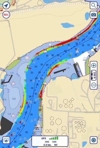
I decided to load the Norfolk to SC track into a navigation program and see where it might lead a stubborn track follower down the wrong side of the channel or otherwise get them in trouble during next fall’s snowbird migration. I didn’t even make it as far as Gilmerton Bridge! Look at the attached screen shot. A southbound vessel going around the inside of that fairly blind curve could have a nasty surprise. This isn’t an artifact of the track being laid down northbound because he was on the wrong side at the next bend for northbound transit just to the south. These tracks are developed from the provider’s GPS records which are then tweaked in shoaling and problem areas according to USACE surveys and other data. It bother’s me that someone being held out as such an expert that some people think they must follow his tracks like they were a train is driving like this.

To be fair, the provider of these tracks also presents lots of information about navigation programs and depth information to assist boaters in maneuvering responsibly around other vessels and complying with the rules of the road. However, he seems very resistant to recognizing that an increasing number of boaters are not looking beyond simply downloading and following the tracks. I’ve urged him to provide a paragraph to his track download sites clarifying what the tracks are, what they are not, and making it clear that responsible navigation will often require departure from them. He’s promised an article for the next addition of an online cruising guide but made no changes to the track download sites.

Are you meeting, and almost running into, these people?


Attachments

  • Bob Track.jpg
    Bob Track.jpg
    122.4 KB · Views: 92
Yep...last one was a guy run me almost into a daymarker because of his tunnel vision....or maybe the center channel hog in the big boat....then again could have been the one.....


I think it's also because so many are unsure of their ability to stay in the channel, it's like those that anchor next to you in a huge anchorage.... you are OK, so they will be.


I get it, but it's a pain in the A**.


Then there are those that take center channel because they think they need it (bigger than you, arrogance, etc). Not all but still enough to come across routinely.
 
Last edited:
Ah yup, the railroad of the ICW. They must learn ANY posted route is a suggestion, modified by common sense and rules of the road.

These are the same folks who get lost when following their GPS while driving their cars.

Then we have the influx of self driving cars....

IMO, if a boater wants to follow a published GPS route, do it 2 miles outside. Also realize you are still required to have a qualified helmsman at the helm and a qualified look out.
Yes I know, many commercial ships go to autopilot, following a route, as soon as they pass the sea buoy and perhaps reducing the number of people on the bridge but, that is their (stupid) decision. YOU must be a responsible boater following the Marine Rules of Navigation. #1 Do everything possible to avoid a collision.
If you want to follow a route like a rail road, put your boat on a flat car and ride inside the trail.
 
Last edited:
I can't speak to the ICW having little experience on that waterway. I have seen since the development of plotters fed by GPS too many boaters who just lay down a line on the plotter and follow the line, probably with the AP following the line. Other vessels and navigational concerns be damned. Now with auto routing and auto route following by the AP being common the problem is getting worse.

psneeld offers a good explanation for some. Of others I suspect laziness. In either case they are letting the machine or someone else make the navigation decisions.

Plotter or paper. Lay down your own course. Learn what it takes to make good navigation decisions. If you are going to use 'experts' routes or auto routing it should only be used as one source of information, guidance if you will. Understand the ap's and plotter's strengths and limitations. Use the ap to enhance safe navigation. Don't hand your navigational authority over your boat to the autopilot.

I know most here on TF already know this. Climbing off my soap box now.
 
Someone steering along a line, even in the middle of the ICW channel isn't too bad much of the time (many places, a few yards out of the channel can be tolerated)...


....it's when they steer towards you thinking you know the good water and keep forcing you out of the channel to the point they are well on your side.


These are the real troublesome ones.
 
Roger, I was almost run down by someone on the track you mentioned in Georgia. The boat was on auto pilot. I could tell because the captain was reading a book.

Last night someone ran into an ATON in Boston Harbor. Sadly there was a fatality. It was pretty foggy. I wouldn’t be surprised if the AP was on and it had been programmed to run from marker to marker.

I don’t think the route is the problem, it’s the ability to insert the route into an AP. It allows the captain to think he doesn’t have to pay attention.

John
 
Didn't know about the published GPS course track tool, but Roger Long's account may explain some of the breathtakingly boneheaded behavior that I have been getting all too accustomed to along this stretch of the ICW (NE Florida). It's typically a shiny newish-looking motor yacht in the fifty-foot range charging along at a very purposeful speed, as if on a tight schedule. The operator acts as if my boat, passengers and I are invisible, except for an occasional languid wave as they squeeze me out of the channel and up against an oyster bed (all without slowing down). If anyone aboard is monitoring a VHF channel, they won't admit to it.

No waterborne idiocy surprises me any more, sad to say. In fact, I'm only surprised when another boater behaves like a pro.
 
I'd almost prefer the straight-liners to those who are totally unpredictable. In some cases they don't even seem to be aware there is a channel, or notice any other traffic. They turn, cut in, cut out, speed up and slow down randomly, and will head right toward another vessel without appearing to even see them. Along one stretch of ICW I watched one of these Bozos cross directly in front of two other vessels, after doing the same to me, forcing each of us in turn to slam it into reverse.
 
I don't think its anything new. There have been magenta line riders for a while. Now its just easier to program the route. You can tell a mile away the ones that won't move over. When you pass, their wakes are still a straight line. And its all types, from the 40 ft Back Coves to cruising sailboats, to the huge express cruisers class, and yes double cabin trawlers. Ill always move over once, then once more. If necessary full stop with 5 short and a wee bit of verbiage. Courtesy is heading for extinction.
 
It would be nice if everyone used and listened to their VHF for guidance.
 
As has been discussed before, VHF is great IF they are monitoring and IF you can identify the boat. Simply calling “white motor yacht northbound at x buoy” won’t tend to get their attention. If they happen to have AIS then you can at least call them by name.
 
As has been discussed before, VHF is great IF they are monitoring and IF you can identify the boat. Simply calling “white motor yacht northbound at x buoy” won’t tend to get their attention. If they happen to have AIS then you can at least call them by name.

AIS is a real game changer IF they have it and use it.
 
It's another reason we do minimal ICW travel, but we realize many aren't comfortable going outside. That is also why the ICW gets so much of this. You have all the inexperienced and uncomfortable piled in with all those with knowledge. I'd suggest writing the provider of the line to tell them they are a problem and need to put a strong warning. I'd also try to radio any boats and then blast the horn at those who don't listen. Sometimes too you have to move to port and let them pass on starboard.

The behavior of boaters (and landowners) on the ICW just is irritating at the best and dangerous at the worst. Some pay no attention to rules, don't listen to VHF, and don't even know the letters comprising AIS. Many decide not to be deterred by other boats and go to the middle of the channel or the left side even as they see fit, oblivious to other boats. Toss in sailors who decide it's fine to tack right across the ICW with boats approaching. Then you get those who go 7 knots and are infuriated by anyone who goes faster and you get fishermen in the channel and homeowners mad at wakes that don't even exist or are small and apparently thought all the ICW was no wake. Then boats ignoring their wakes completely and not even distancing from other boats, just flying by as they wish. Weekends and holidays you bring out even more of the inexperienced and blind boaters.

If I want to sight see then I'll take the ICW but if I want to get to the next place, only when conditions force me. I know for many here it's the best way to travel and I hate, for their sake, that it's such a zoo at times.
 
It's really not that bad....


Like many TF discussions, the chances of our boats sinking, burning, exploding, colliding, being robbed, etc...etc....

.....are WAY less than what gets bantered back and forth here. I am not saying that any or all aren't possible...but with even the teeniest amount of care....most bad things are a long shot at best.


Sure people hog the channel and drive irresponsibly...if you are even the most mediocre boat handler, a simple chopping the throttle, turning of the wheel...heck just paying attentions and you can travel tens of thousands of miles with out any really close calls.

You're right that we make it sound worse here than it is. That's because that's the nature of the topic of this discussion.

We've learned two ways of navigating through it all. One is when we're sightseeing and we yield and back off and away to everyone. Wherever they want to go, we let them. The other is when we're in a hurry to get somewhere and we maintain ourselves on plane as much as possible (which has little wake) and we dodge all the others sweeping as wide and distant from them as possible. We try to stay to the right, but if they want that half, then we're as far to the other side as possible.

We do radio and have about 50% success.
 
There are stretches of the ICW that going fast is a real issue....but there are many open areas too that speed is not an issue.

An experienced mariner on the ICW knows generally when and where to travel it to avoid the most problems that speed enhances...many suggest not traveling on weekends which I usually ignore too, but there are stretches that weekends bring out challenges to one's patience. If speed or lack of delay is desired...planning to make the occasional run offshore is easily fit into many voyages. Sure there are weeks and times of year that offshore is not an option...but then the ICW just needs to be approached with caution.


In the big scheme of things...most weeks I was transiting the ICW between NJ and FL, the most aggravating 4 hours I had were on the phone straightening out bank or billing issues, not the moment here and there where bad boaters crowded me or cut me off.


Sure I like to bitc* about the poor manners or ignorance on the water, great for sitting at happy hour telling sea stories...but does it keep me from using the ICW when I want to...heck no.....
 
Last edited:
This topic was hashed out at length on FB pages. The author suggested that Bob 423 had a responsibility to be more assertive in communicating the manner and limits in which his tracks should be used. Bob, appropriately, showed the disclaimers and warnings were posted, and it was the responsibility of the user to use them responsibly.

There is no grand solution. Idiots will be idiots. It will ever be thus.
 
Having an intimidating bow does not assure others will respect proper seamanship. Some boaters run on automatic.
 

Attachments

  • IMG_2277.jpg
    IMG_2277.jpg
    99.2 KB · Views: 47
Paint the track author's burgee in large size on something you can hold up to the guy not monitoring his VHF and apparently following the track. Maybe he'll at least have a set of binoculars, and if he does, he will know he has a problem. :)

Before holding up the burgee try calling to the guy heading relentlessly your way and telling him you are following the author's track too!

I tried using one of his tracks through a very iffy portion of the ICW north of Charleston and found it wanting at best. No more after that.
 
Look. I am just asking one simple thing of the fellow that provides these tracks. Every place where a person might learn about these tracks and every place where they can be downloaded, they should see something like this short paragraph as the first description:

These GPX tracks show, from the best information available, the line of deepest water from Norfolk to Key West. They are only intended to be followed as a navigational route in the absence of other vessels. When other vessels are in sight and a passing or meeting situation is developing, the USCG rules of the road will often require a departure from these tracks. Users of these tracks must be proficient in the use of navigational systems and depth information that will let depart from the tracks safely and comply with the rule to move to starboard when meeting or passing vessels in narrow channels. A vessel being on one of these tracks has no special privilege under the rules of the road which every vessel should have a copy of on board.

I understand that a very good article will be coming out in a future cruising guide but the track guy, in extensive discussions, has been remarkably resistant to providing such a clarification in conjunction with the track downloads which would cost nothing and take only a few lines on his blogs and web sites. If I were a new boater and I followed his track southbound around that blind bend on the Elizabeth River, I think I would have a case like the person who sued Garmin over the Magenta Line that NOAA had already dropped.

This is not about making the ICW idiot free. If my suggestion was taken, I doubt we would see any noticeable reduction in operational stupidity. However, our experience with the Magenta Line followers tells us that there will always be a subset of nervous boaters clinging to a line without regard to other vessels. These tracks have achieved mythic status among many boaters. That gives their provider great credibility. With that comes responsibility. I’m not asking the track provider to solve a problem which is not of his making but just to do something simple and no-cost to help insure that he is not contributing to it.
 
Sure, a simple warning.


Now as a realist...who here reads the 2 pages of warnings in the front of every new thing they buy?


Plus in my estimation...unless driving barges down the ICW (which I have the NJ section) ...someone hogging the middle of the channel is not nearly the problem of those that steer for you knowing you have just proven deep enough water.
 
I think you are reading too much into this and are trying to pin a few encounters with inexperienced boaters on one guy or one data set. In just the twelve or so years I have been boating, I find people that hog the channel nearly every trip out. I don't ask them why and don't really care and I am sure many of them have never even heard of Bob OR his tracks. However, since you have had someone admit that they were following the track and using it as their misunderstanding of the rules of the road, you grabbed a broad brush and started painting. By opening this thread, I feel like you are on some sort of crusade to have Bob (if that is actually his name :) add a disclaimer to his tracks (that zero people will read!) or else you will continue to call him out all over the interwebs. There was no collision. Nobody crashed into the rocks. All people have to do to fix it is use their superior boating skills to steer to the side of the channel for a minute or two and avoid a hazard. It's okay... everything will be okay. Over time, new boaters will become experienced boaters and things will get better.
 
If you don't like the way I drive then get off the side walk! Or, Yes as a matter of fact I do own the road!
 
Roger...please.... I hope I am not getting you too wrong.


I was 1000% your idea of getting boaters to use Ch13 on the ICW thread. In lock step for sure. There was a few who disagreed but like many things, take their experience into account. Your first paragraph in this thread refers to confirmation by others on social media.


I would hope that your experience has told you that many controversial subjects on boating it is easy to find masses that agree...whether it be on jet skis, the looks of certain boats, how to use a spring line, etc...etc....


Yet the more experienced one gets, the greater the realization of the knowledge pyramid in boating. So many have so little experience...knowing what they are supposed to do is a challenge....those that understand why so many can't follow rules or customs or courtesies are few and far between.


I agree that a disclaimer is always a good idea. If I tell someone how to get going again even it doesn't follow ABYC rules...then yes to the disclaimer, but no to that you will die trying my suggestion. Same as this...I thnk the resistance you will hear is not to the disclaimer as much as it its to just how big a problem it is or that those following these "digitized" routes will adapt when meeting traffic.


Good luck in changing the great unwashed, but I get the effort.
 
Idiocy is not confined to the ICW. It happens in all waters and it is becoming an increasing problem, with the new generation of boat users; that’s all they are, boat users, not seamen, not mariners, not even boat operators.

We seldom run one wide, often two, frequently three and sometimes four. At 60 feet a section, do the math. Three wide is 180 feet, or more than six times our beam. That’s if the tow is tracking true. It’s not unusual for the tail end to be kicked over another couple hundred feet.

So we get nouveau canotier, chugging up the middle; zero situational awareness. Calls and signals are lost on these ones.

The picture at sunset is in a strait 12nm wide, yet there they are, needing to make an abrupt course change, after a near port to port.

Manning the winch, prepared to run the drum, is becoming routine.
 

Attachments

  • Coaster.jpg
    Coaster.jpg
    140.2 KB · Views: 52
  • 3 wide.jpg
    3 wide.jpg
    42 KB · Views: 53
  • 14 .jpg
    14 .jpg
    96.3 KB · Views: 57
You asked Bob, on FB. Forcefully. Bob pointed out the warning that has existed for some time.

You asked. He answered.

So what’s the goal now? Force him via pressure to do things the way you personally think they should be done?

Look, your point is valid. But it’s been made.
 
Bad boaters are a problem worldwide, but I think the point of the OP is that if someone (corporate or amateur) suggests a trackline though a particular area, they should take on the responsibility of notifying the user to the Nth degree that opposing traffic has certain navigational rights too.
 
I don’t know Bob. I don’t use his tracks. But his warnings are visible. I don’t get the continued campaign.

Enough said. This isn’t worth more time.
 
Bad boaters are a problem worldwide, but I think the point of the OP is that if someone (corporate or amateur) suggests a trackline though a particular area, they should take on the responsibility of notifying the user to the Nth degree that opposing traffic has certain navigational rights too.

Exactly. And, especially when the track takes them down the wrong side of a blind curve in a VARY high traffic area with lots of barge tows. Whether these tracks are a significant part of the idiot boater problem is an open question but the fact that a large number of boaters take them as gospel is not. They have said so, over and over, on social media. Those boaters are less likely than most to use AIS, keep track of security calls, or know what to do when that barge tow appears around the bend.

For the record: I love and admire everything the fellow does except for this narrow issue. I would be as disappointed as anyone if his tracks were not available, at least for the problem areas.
 
Back
Top Bottom