What size chartplotter display

The friendliest place on the web for anyone who enjoys boating.
If you have answers, please help by responding to the unanswered posts.
I don't disagree with you, the only thing I'd point out is I'd bet, given your experience and longevity, you use electronic charts as, well, digitial versions of old paper charts. You still look for ATONs and navigate channels visually. A small display would be okay.

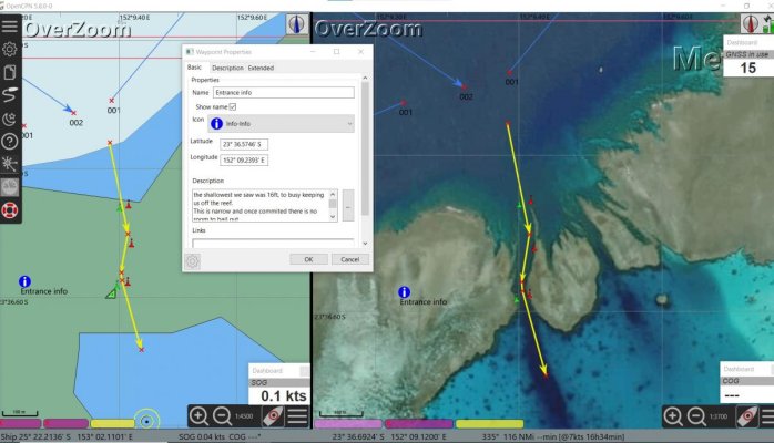
But alas, the world has moved past ATONs. Many boaters, perhaps most, perhaps vast majority, use digital display as primary reference for channel - just as they do Google Maps in their car. I suspect they spend a LOT of time looking at the screen to assure they are in the channel. Used like that, a small screen simply won't cut it.

Best I can tell, you are a dying breed. I'm in the gurney next to you.....

Peter

I believe you are correct and would also argue that we are less safe on the water because of it. Keeping your eyes outside of the boat is the best way to navigate, I see too many credit card "captains" wandering down the middle of a tight channel with their head glued to their dash. Very few 12" MFD's were in use 25 years ago and we did just fine.
 
On a modern chartplotter, you can overlay chart, radar, and AIS and it works pretty well - even at 9". I'd rather do that on a 1200 nit screen than squint at a large 400 nit screen.

Wife prefers overlay. I prefer a separate screen for radar often. Find I have less trouble picking up small targets and making sure targets are real. I also find although I use the presets I also tune and that’s easier on a non overlay screen. Use all 3- overlay, split and its own screen. On all screens change mag frequently. Never squint. Lol.
 
On a modern chartplotter, you can overlay chart, radar, and AIS and it works pretty well - even at 9". I'd rather do that on a 1200 nit screen than squint at a large 400 nit screen.

Can do that on OpenCPN plus do satellite imagery overlays on the fly so as to see the channel through the reef to see if it matches often unreliable charts.

Never needed to squint to see anything on our screens - zoom in and out as much as you like at the roll of a mouse wheel or point and click + - buttons
 
Last edited:
.

3. Learning curve. There are non-MFD options such as running PCs, tablets, etc. running some sort of third party software such as OpenCPN. These are viable but require investment of time to understand them and setup properly.

As does using an MFD and button driven plotters

Learning curve was far less and ease of use is much easier on PC driven device.
If you use a computer for anything, OpenCPN is intuitive

Simply point to icon with mouse and click
Vs
Menu > mode > navigation > icon >.......... now what was I looking for again and where is the manual?????

Seriously, to much investment in time for me and couldn't do the simplest of tasks without finding the manual to do it.

Agree, some chartplotters have sub menus so deep many boaters have them for years and never knew all the functions it had...of course NOT reading instructional manuals is a constitutional right in the US.... it the one right after buying stuff that you rarely use.... :D
 
As does using an MFD and button driven plotters


Learning curve was far less and ease of use is much easier on PC driven device.

If you use a computer for anything, OpenCPN is intuitive


Simply point to icon with mouse and click

Vs

Menu > mode > navigation > icon >.......... now what was I looking for again and where is the manual?????


Seriously, to much investment in time for me and couldn't do the simplest of tasks without finding the manual to do it.
There is a significant percentage of people who have tried OpenCPN and given up in frustration. I'm one of them. Simi, I almost always respect your posts. But calling OpenCPN "intuitive" is a bridge too far.

Peter.
 
I would love to know the actual number of likes/dislikes for OpenCPN, sure seems to be a hit from what I read and see in the field. Seems like even a lot of foreign skippers are always on line asking on how to add gadgets so they must be satisfied with the basic nav performance.

Just about every serious cruising friend I have switched to OpenCPN if they had an inside steering station.

On guy with a 48 Lagoon Cat built a Raspberry PI setup for the cat he was so enthused.

Like any plotting software, the basics are just as easy as any plotter I have ever used.

True a few Nav features take a bit of practice but without reading any of the online literature, it did everything I needed it to do in all my travels.

True some plotters like Garmin use very intuitive sub menus (at least they did years back, haven't used one lately).... but the rest I would have to say really aren't any easier or harder than OpenCPN....it just takes muddling though each of them.
 
Last edited:
I would love to know the actual number of likes/dislikes for OpenCPN, sure seems to be a hit from what I read and see in the field. Seems like even a lot of foreign skippers are always on line asking on how to add gadgets so they must be satisfied with the basic nav performance.

Just about every serious cruising friend I have switched to OpenCPN if they had an inside steering station.

On guy with a 48 Lagoon Cat built a Raspberry PI setup for the cat he was so enthused.

Like any plotting software, the basics are just as easy as any plotter I have ever used.

True a few Nav features take a bit of practice but without reading any of the online literature, it did everything I needed it to do in all my travels.

True some plotters like Garmin use very intuitive sub menus (at least they did years back, haven't used one lately).... but the rest I would have to say really aren't any easier or harder than OpenCPN....it just takes muddling though each of them.
The first challenge with OpenCPN is managing the layers of charts. That is a unique problem to OpenCPN. Other nav packages do not require the user to organize charts into layers.

I liken it to the old DOS days of windows. If you understand the base operating system and are okay with reading reams of instructions, it serves the purpose well.

OpenCPN is extremely flexible. And perhaps over time you get the hang of adding features in their environment. But in my opinion, the learning curve is steep even for base features. MFDs are almost usable out of the box. Sure, there are advanced features that can be frustrating, but compared to Coastal Explorer (a competing PC based nav package), OpenCPN is difficult and clunky.

By far, the biggest advantage OpenCPN has going for it is that's its free. If folks had to pay $300 for the base software plus occasional upgrades, it would be a ghost in 5 years time.

My opinion.

Peter
 
As I've mentioned before, the best thing for us about OpenCPN is being able to make working charts on the fly.

The image at left of split screen is what Cmap shows - minus the yellow line and marks
On the right is the georeferenced satellite overlay knocked up in a few minutes when about 30 minutes out.

This allowed us to take advantage of a protected lagoon vs putting up with another 3 hours of deteriorating conditions to the next easier but of reef.

The first challenge with OpenCPN is managing the layers of charts. That is a unique problem to OpenCPN. Other nav packages do not require the user to organize charts into layers.

.

I find it's simple

I make the overlays and in the instance shown, seeing as they are a KAP file and location is Queensland they are dropped in a file called QLD KAP.
Same if doing a Navionics or Cmap overlay, then they'd be KAP CHART file.

Once scanned in, which is the click of a button and several seconds they appear as the red tiles seen at bottom of screen

Turn on and off by clicking on them as required.
 

Attachments

  • Screenshot 2023-07-20 075252.jpg
    Screenshot 2023-07-20 075252.jpg
    97 KB · Views: 40
I have no idea what "layering of charts" means.

Granted Raster are on their way out...but all I did was download the East Coasts charts, build the database (a couple keystrokes strokes and a heckova lot better than sending hundreds of dollars for proprietary charts that I found more inaccurate than NOAA's).

Then drove over 20,000 miles with minimal effort.

I still keep it on my phone, tablet and computer to answer questions on the new or with my phone while out and about talking to other boaters.

No whining about going down to the boat to solve Nav problems (though it seems like lots of folks in addition to wasting tons of money on plotters, they love to buy apps for their phones/pads too. Never made that kind of money to spend when something I find extremely useful for free.

Just one of those things that I will have to agree to disagree.
 
Last edited:
I have no idea what "layering of charts" means.

Granted Raster are on their way out...but all I did was download the East Coasts charts, build the database (a couple keystrokes strokes and a heckova lot better than sending hundreds of dollars for proprietary charts that I found more inaccurate than NOAA's).

Then drove over 20,000 miles with minimal effort.

Just one of those things that I will have to agree to disagree.
Simi touched on need to sequester charts in files - tiles. Otherwise you end up with dozens of bars across the bottom of the screen and the program underperforms. Other nav programs do that for you - and have for years. For US, base charts are the same ENCs available for free.

I am impressed with the dual view Simi shows of satellite and chart. Very helpful. I've tinkered with developing charts from satellite images. I'm sure it's simple once you do it a few times. "A few key strokes" does not come close to describing my early efforts, thus the comments about learning curve.

Clearly there are some features in OpenCPN that are cool - weather for example (though that is pretty clunky with an email interface, not unlike the old SailMail/SSB). Last I checked, OpenCPN also was one of the few that made ZoC (zone of confidence) depth data accessible.

OpenCPN seems to rely on wonky geeks to improve. They are deep into the nits and don't do much in regression testing to make the program accessible to non-geeks. They preach to their choir who are happy to invest the time to save money.

Peter
 
Wow...for a bunch of guys who grew up with paper and pencil nav..... we now need wonky geeks to give us nav gear? Probably the same type guys, just working independently rather than for MFD manufacturers.

As I said, took a old laptop, bought a $39 GPS puck, downloaded OpenCPN, downloaded some charts and was navigating withing hours. I can do basic computer stuff, but certainly no geek.

Even doing what Simi did, but to a simple degree....a few years back the ICW crossing the St Johns river near Mayport, Fl has some major changes happen. No one including the Corps or the USCCG could keep up with shoaling changes. I just imported a Google Earth file and plotted the best guess waypoints being offered by various sources and then displayed it. Took me a bit but once the flow was set, it's pretty easy to do.

Still have no idea what you are talking about layering (never cared to go too deep into the program) but I do remember some bars on the bottom of the screen yet no underperforming.

I never added radar, ais, weather......blah, blah because it wasn't needed for my style of cruising. I doubt the OP in San Fran waters in a 24 footer doesn't need all that either. If he's headed for Alaska...different story.

Just like many MFDs....you can use them for the basics, or delve into all their features that really aren't needed but advertised because the units "can do all that".... same with OpenCPN for me at least.... most people I know love it and add all the other stuff... I just didn't need it because I had my trusty 7" Raymarine display for Radar (that I rarely needed or used) and fish finder which was nice and probably used a lot compared to all the other electronics for ACIW nav.
 
Last edited:
To bring this back to the OP's question, there are indeed options that are even less expensive than a small MFD. OpenCPN running on a laptop is free plus cost of a GPS and hardware. Some folks love it, others are frustrated by it (especially if you want to interface with Autopilot or other onboard devices routinely integrated with an MFD). There are many considerations to running on a consumer device (laptop, tablet, or phone) vs an onboard MFD designed for use in a bright, bouncy, and wet environment. But you can save some money by going with a consumer grade platform. For people who are highly price-sensitive and either boat alone or who's spouse is fine with the learning curve, it's a good option.

To the original question about size of an MFD, bigger is definitely better. Price difference is exponential so you have to make a decision whether it's right for you. I doubt there are many who say "wish I'd saved $2k and gone with a smaller MFD." The full power of an MFD is to display multiple data streams simultaneously, some in a split-screen. In my opinion, 12-inch is a reasonable size. Smaller is workable, but if you can afford the 12-inch, I sincerely doubt you will regret the purchase down the road.

Of course, if you are truly old-school and reluctant to change like some on TF, you can still buy ChartPaks and near-obsolete gear with under-sized displays and call it a day. You'll save a couple grand. If that's a meaningful savings given the purchase cost and holding costs of a boat - even a 24-footer, then it may be a good decision for you.

Peter
 
Last edited:
Reluctant to change?.... I might say that's really the MFD crowd..... commercial fishermen and commercial vessels were using computer based navigation 25 or more years ago.

I guess I find recreational coastal cruising, especially in familiar waters or easy to nav waters way simpler than needing "data streams".

It's not that I am resistant to change as much as I am resistant to waste.

If you need all those electronics in giant displays, go for it....I know few that actually benefit from all of it (most are regular posters here on TF)...most boaters (even many professional captains) I know are nothing like this crowd.

Condensing all this back and forth in my mind is as simple as....what do you really need to safely navigate? That can be different things for different skippers. So it's just a matter of what makes you happy or comfortable or whatever.

Most boaters NEVER utilize their boats to their dreams...so much is just wasted boat and money....buy to your current needs and if those change...probably by then the gear is "obsolete" in some peoples minds.... so sell the old stuff and buy the best when you head out on the big one.
 
Last edited:
Reluctant to change?.... I might say that's really the MFD crowd..... commercial fishermen and commercial vessels were using computer based navigation 25 or more years ago.

I guess I find recreational coastal cruising, especially in familiar waters or easy to nav waters way simpler than needing "data streams".

It's not that I am resistant to change as much as I am resistant to waste.

If you need all those electronics in giant displays, go for it....I know few that actually benefit from all of it (most are regular posters here on TF)...most boaters (even many professional captains) I know are nothing like this crowd.
Not sure of your point. Serious boaters I know- commercial or recreational - invest in technology to enhance their experience. That's why they were running chartplotters 25 years ago. It's why fishermen spend plenty on sonar and fish finders and nav systems.

But if boating has become rote and all one does is ply familiar waters, no doubt, a nav system can be a distraction and a waste of money. That wasn't the OPs question, but if that's his/her use profile, definitely consider doing nothing.

Peter
 
I've never found the need to layer charts in OpenCpn, and I have the whole NOAA and CHS raster chart catalog loaded at all times, one layer. Could be on a slow RaspberryPi setup with limit memory it gets slow. The scrolling and zooming on my laptop is faster than the (recent model) chartplotter with the same charts. One thing that does slow it down a bit is displaying tides and currents. The plugin seems inefficient.
 
No whining about going down to the boat to solve Nav problems (though it seems like lots of folks in addition to wasting tons of money on plotters, they love to buy apps for their phones/pads too. Never made that kind of money to spend when something I find extremely useful for free.

Just one of those things that I will have to agree to disagree.

Aquamaps is $20 for a lifetime of free upgrades on 3 devices. I have it on a 12" tablet in the pilothouse and on my smartphone for dinghy excursions. Also nice to have when riding on someone's boat. In the relative cost of boating, $20 is a rounding error.

Ted
 
Aquamaps is $20 for a lifetime of free upgrades on 3 devices. I have it on a 12" tablet in the pilothouse and on my smartphone for dinghy excursions. Also nice to have when riding on someone's boat. In the relative cost of boating, $20 is a rounding error.


Ted
Thanks Ted. US charts are now $30 for lifetime access. Agree this is a bargain. App in general looks pretty useful and includes weather overlay and Active Captain integration. Can also integrate with AIS if you have one available broadcast off wifi.

Other regions are available for additional fees, mostly for 1-year subscriptions. Pacific Mexico, for example, is $70/yr for Blue Latitude charts. Bahamas is $36/yr or $100 for lifetime. Also a decent value.

Peter
 
Aquamaps is $20 for a lifetime of free upgrades on 3 devices. I have it on a 12" tablet in the pilothouse and on my smartphone for dinghy excursions. Also nice to have when riding on someone's boat. In the relative cost of boating, $20 is a rounding error.

Ted

Thanks Ted will keep it in mind when looking at a new boat (CC) soon.

Got started on OpenCPN long before many of these apps and phones/tablets matured and stuck with it....especially in the lean years when even $20 bucks wasn't a rounding error... :blush:
 
How does Aquamaps compare to Navionics in terms of ease of use and learning curve?

And Aquamaps does not “speak” NMEA2000, true? Wouldn’t that be nice?
 
I would love to know the actual number of likes/dislikes for OpenCPN, sure seems to be a hit from what I read and see in the field. Seems like even a lot of foreign skippers are always on line asking on how to add gadgets so they must be satisfied with the basic nav performance.

Just about every serious cruising friend I have switched to OpenCPN if they had an inside steering station.

On guy with a 48 Lagoon Cat built a Raspberry PI setup for the cat he was so enthused.

Like any plotting software, the basics are just as easy as any plotter I have ever used.

True a few Nav features take a bit of practice but without reading any of the online literature, it did everything I needed it to do in all my travels.

True some plotters like Garmin use very intuitive sub menus (at least they did years back, haven't used one lately).... but the rest I would have to say really aren't any easier or harder than OpenCPN....it just takes muddling though each of them.


We must have a different circle of friends. Virtual all of mine have tried and given up. Currently have it on the laptop. Occasionally retry to learn it. Repetitively unsuccessfully. Particularly have troubles updating charts using a Wi-Fi hotspot. Much easier on those few occasions in a slip to update the MFDs and IPads much more reliable so can start it up and go to sleep or off to another project.

I do make use of the ancillaries for fuel availability and price, slips, weather, currents (not just tides), anchor field ratings and such. None of that is available on OCPN. Those convenances are valuable to me. Particularly when headed in a direction not a fixed destination.

Most MFDs allow you to set up multiple customized screens. Currently run 6-8. Once set up one tap and you have want you want without running through menus. Do use the menus for radar and topology as my wants change with activity and situation.

What can I say? I will say no more. :banghead:
 
What can I say? I will say no more. :banghead:

Seems currently folks have moved on.
Some avoid the expense of MFDs going to pure pad nav. Some very remarkable voyages done that way.Open won’t run on a pad.
Some racers like TZ pro with the racers and weather modules.
Some cruisers like nobeltec.
But many like branded MFDs with IPad backups.
Know folks who had(have) open. Don’t know any who are still using it as their primary. Many like Peter and me just found it too inconvenient and moved on.your mileage may vary. Just sharing current real world experience. Pretty innocuous post .
 
Last edited:
How does Aquamaps compare to Navionics in terms of ease of use and learning curve?

And Aquamaps does not “speak” NMEA2000, true? Wouldn’t that be nice?
Based on Ted's recommendation, I downloaded AquaMaps but have only tried it on my Android phone. It's similar to Navionics but seems to have some extra features, albeit at a modest price.

Yes, a license to lifetime US charts is $30. Canada is $25 (USD) for lifetime. Both are $50/lifetime. Most other countries are annual subscription.

Their website implies you can connect wieelessly to your boats instruments and integrate.

One interesting feature is their "Master" upgrade. For $15/yr, gives you AIS, wx forecasting, weather buoys, and some route information.

I like Navionics but at first glance, I easily see why Ted/OC Diver recommended AquaMaps. It's a decent App. Tablet version would be great.

Peter
 
Getting back to the OP's original question; one factor in choosing screen size is how close it will be to your eyeballs. Eg our 12" screen in our NT42 pilothouse is about 3' from my eyes while the 7" screen in the dinghy is about 18" away. There is a slight difference in detail I suppose but split screens are similarly effective.
 
And then we get back to chart inaccuracies.
Navionics, Cmap, ALL charts are continually proven to be inaccurate if venturing off the well beaten path.

The only ones that seem accurate are those in very well travelled areas frequented by shipping
Or those you have made yourself using satellite overlays and personal soundings

Yesterday speaking to a cruiser who followed Navionics, was well clear of the reef according to charts - until he wasn't
Luckily he was steel and he bounced off.
The reef is very CLEARLY visible if making and using sattelite overlays
 

Attachments

  • Screenshot_2023-07-21-07-08-16-529~3.jpeg
    Screenshot_2023-07-21-07-08-16-529~3.jpeg
    79.8 KB · Views: 25
I just made a 4 hour run through 1/4 mile visibility fog. I was in a new to me area full of broken islands and rocks. I had my radar on my 9" screen and I ran navigation with radar overlay on my 14" screen. The overlay never showed those pesky kayaks. The radar only screen showed them. I can't say how things would have gone if I did a split screen on the 9".
 
How does Aquamaps compare to Navionics in terms of ease of use and learning curve?

And Aquamaps does not “speak” NMEA2000, true? Wouldn’t that be nice?

I'm very happy with Aquamaps. You can try it for free, but you will only get 3 map areas (which is more than enough to see if you like it). For what's now $30 is still incredibly inexpensive.

So here's the rub. The people at Aquamaps aren't going to pay the coin to have Windows licensing, so it only works on Android. But, if Apple is your preferred flavor, I'm told it will run on their laptops, tablets, and phones. So, you may be able to run it on an Apple product that you can use an interface to NEMA 2000. Not sure what all can be displayed from NEMA 2000 onto Aquamaps, but I would prefer a more precise GPS receiver. My tablet and Smartphone aren't bad, but the marine GPS units can pretty much put you in your boat slip.

Ted
 
Aqua Maps will easily connect to your N2K network on a tablet or phone if your network is wifi enabled. Connect device to the wifi network, launch AM and in settings use external gps through port 10100. This will give you real time depth, sog, direction, coordinates, xte and most data on the N2K network. For AIS, Aqua maps master is needed but targets will the appear complete with all info contained in the target data.

This also works on Navionics for tablets etc. I’ve been using this for 8 years on our boat connected to two Lowrance HDS Gen 2 MFD’s, AIS supplied by a link 8 vhf (N2K connected).

At $50.00 lifetime it’s a bargain for US and Canada (at least until Garmin buys them out[emoji33])

James
 
Poor wording of my question. I get that Navionics (and presumably AquaMaps) connect with NEMA 2000 networks, but I don’t think either will issue heading commands to an autopilot over that network and therefore can not be used to steer a course or series of waypoints.

I believe iNavX will do that, but I have not delved deeply enough into that app to know how it is inferior to Navionics or AquaMaps.
 
Back
Top Bottom