You are using an out of date browser. It may not display this or other websites correctly.
You should upgrade or use an alternative browser.
You should upgrade or use an alternative browser.
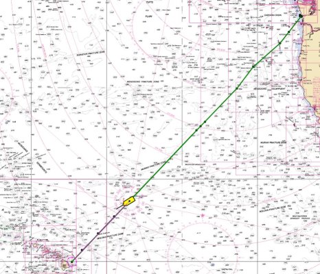
To Hawaii
- Thread starter Delfin
- Start date
The friendliest place on the web for anyone who enjoys boating.
If you have answers, please help by responding to the unanswered posts.
If you have answers, please help by responding to the unanswered posts.
OP
OP
Delfin
Grand Vizier
- Joined
- Jan 20, 2010
- Messages
- 3,850
Correct. Full keel with a skeg mounted steel rudder does a pretty good job of protecting the prop. Spurs to chew up fishing lines, non electronic CAT 3306, so not very high odds of a sufficient mechanical problem to need them, but if so, I can make around 3 knots off the wind from beam to broad reach. Not beating off any lee shores, however.@Delfin, so your get home power is only your sails, no genset or aux engine?
OP
OP
Delfin
Grand Vizier
- Joined
- Jan 20, 2010
- Messages
- 3,850
The Grib shows that, indicating 15 knots, but from the stern quarter, so no biggie. We'll see soon....Delfin, on my long-ago crossing the wind picked up quite a bit as we closed on HI.
The channel effects seem to begin well before you spot that green dot/line on the horizon.
OP
OP
Delfin
Grand Vizier
- Joined
- Jan 20, 2010
- Messages
- 3,850
Having serious doubts about my crewman Dr. Jeff Peck. He just made a steak sandwich. WITH KETCHUP. Going to keep my eye on him.....
Last edited:
OP
OP
Delfin
Grand Vizier
- Joined
- Jan 20, 2010
- Messages
- 3,850
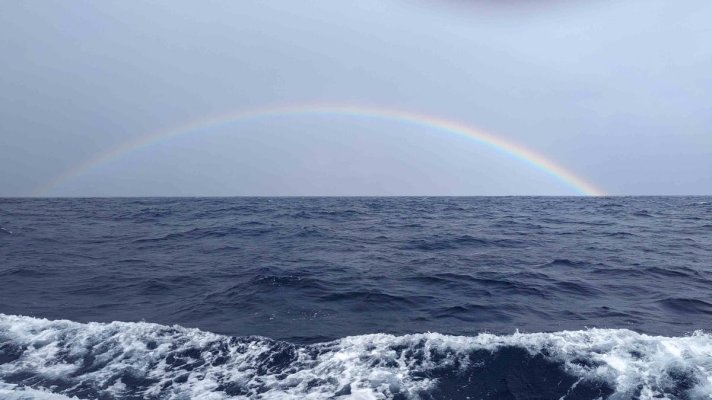
610 miles from Hilo. Conditions remain very benign with following seas and mild winds. If we were to do a 180, it would not be anywhere as relaxing, but fortunately, our destination is downwind.
Encountered a fishing boat last night without AIS near the Huddell Sea Mount, the top of which is 9,000 feet down, but still 9,000 feet above the surrounding sea floor. For the first time, the depth sounder showed lots and lots of fish, but being pitch black, I passed on blind fishing, and had to settle for flying fish found on the deck at daylight. Pretty amazing that a seamount like this would cause a congregation of life, but there you go.
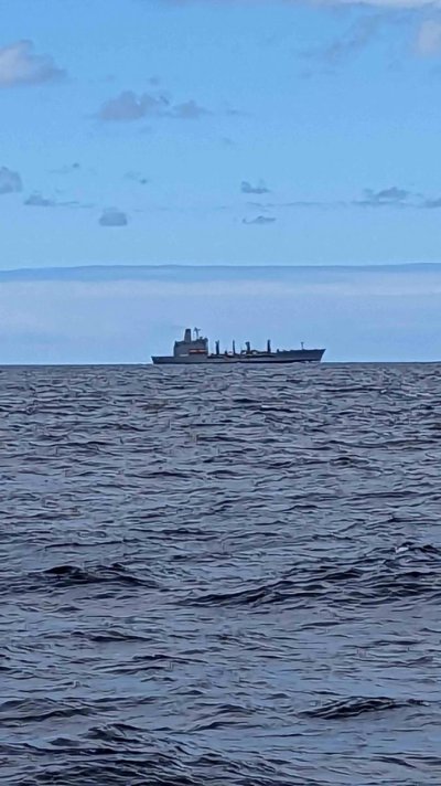
Also encountered today a naval vessel of unknown origin. Naval gray, no AIS, no markings as to country, but I'm pretty sure it was a naval supply ship. Anyone recognize this vessel form?
Encountered a fishing boat last night without AIS near the Huddell Sea Mount, the top of which is 9,000 feet down, but still 9,000 feet above the surrounding sea floor. For the first time, the depth sounder showed lots and lots of fish, but being pitch black, I passed on blind fishing, and had to settle for flying fish found on the deck at daylight. Pretty amazing that a seamount like this would cause a congregation of life, but there you go.
Also encountered today a naval vessel of unknown origin. Naval gray, no AIS, no markings as to country, but I'm pretty sure it was a naval supply ship. Anyone recognize this vessel form?
Attachments
Fletcher500
Guru
I would guess Replinishment/Oiler. If you see a blue and yellow band around the top of the stack, its a US ship.
IRENE
Guru
- Joined
- Jan 8, 2016
- Messages
- 1,254
- Location
- British Columbia
- Vessel Name
- Irene
- Vessel Make
- Nordhavn 40II
Kaiser Class replenishment oiler?
Possibly:
https://en.wikipedia.org/wiki/Henry_J._Kaiser-class_replenishment_oiler
Possibly:
https://en.wikipedia.org/wiki/Henry_J._Kaiser-class_replenishment_oiler
OP
OP
Delfin
Grand Vizier
- Joined
- Jan 20, 2010
- Messages
- 3,850
It did have that, but I thought all US Navy ships have numbers. I couldn't see a flag either, but I was 6 miles away.I would guess Replinishment/Oiler. If you see a blue and yellow band around the top of the stack, its a US ship.
OP
OP
Delfin
Grand Vizier
- Joined
- Jan 20, 2010
- Messages
- 3,850
Yep. I think that's it. Thank you.....
OP
OP
Delfin
Grand Vizier
- Joined
- Jan 20, 2010
- Messages
- 3,850
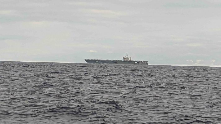
The presence of the oiler might be explained by the appearance of what I am pretty sure was an Enterprise class nuclear carrier coming from the same direction the next day. Perhaps providing fuel for the airplanes?
Helicopter circled around us about 5 times, as we were within around 4 miles. Oddly, no companion vessels, except maybe an invisible sub, but I was surprised not to see any cruisers or destroyers lingering about.
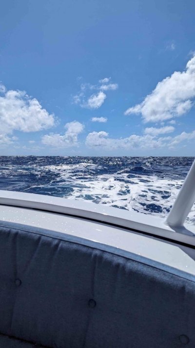
470 miles out of Hilo. Slowed down to avoid arriving at dark but because of following seas, we're still doing 6.8 knots, but only burning 2.3 gph.
Helicopter circled around us about 5 times, as we were within around 4 miles. Oddly, no companion vessels, except maybe an invisible sub, but I was surprised not to see any cruisers or destroyers lingering about.
470 miles out of Hilo. Slowed down to avoid arriving at dark but because of following seas, we're still doing 6.8 knots, but only burning 2.3 gph.
Attachments
Fletcher500
Guru
It did have that, but I thought all US Navy ships have numbers. I couldn't see a flag either, but I was 6 miles away.
https://en.wikipedia.org/wiki/Military_Sealift_Command
OP
OP
Delfin
Grand Vizier
- Joined
- Jan 20, 2010
- Messages
- 3,850
That explains it, thank you.
- Joined
- May 11, 2019
- Messages
- 3,623
- Location
- United States
- Vessel Name
- Muirgen
- Vessel Make
- 50' Beebe Passagemaker
The presence of the oiler might be explained by the appearance of what I am pretty sure was an Enterprise class nuclear carrier coming from the same direction the next day. Perhaps providing fuel for the airplanes?
Probably a Nimitz class aircraft carrier. The Enterprise was a one off boat, no sisterships.
OP
OP
Delfin
Grand Vizier
- Joined
- Jan 20, 2010
- Messages
- 3,850
You're right. I misquoted my ex Navy crewmate, who said it was Nimitz class .Probably a Nimitz class aircraft carrier. The Enterprise was a one off boat, no sisterships.
hoplite808
Member
- Joined
- Jun 2, 2023
- Messages
- 14
It was likely the USS Nimitz. I saw her leave Pearl Harbor the other day. I think she is just heading back to her home port.
Dashash
Veteran Member
- Joined
- Nov 13, 2020
- Messages
- 72
- Vessel Make
- Bristol 42
Too funny. I'm returning from a 7mo deployment on the Nimitz. We are off the coast of CA now. Air Wing fly off today. Flying one of our F18s off to Lemoore, CA and will be home tonight. We left Hawaii on the 23rd. Have averaged about 30 knots SOG, at least. Have been following your posts and wondered if I'd see you out here.
That other ship you saw is a Merchant Marine supply ship for our strike group. We also have the USS Decatur and USS Bunker Hill in tow. Not sure where they are now, but they generally stay on our flanks just on the horizon. Our other ships are homeported in Hawaii.
Have a safe trip to HI. The weather was beautiful there.
OP
OP
Delfin
Grand Vizier
- Joined
- Jan 20, 2010
- Messages
- 3,850
. Wow. What a coincidence. You circled us at around 3 miles distance. We assumed the Captain was using us as a reference point for some maneuvering exercise. Next time, wave!Too funny. I'm returning from a 7mo deployment on the Nimitz. We are off the coast of CA now. Air Wing fly off today. Flying one of our F18s off to Lemoore, CA and will be home tonight. We left Hawaii on the 23rd. Have averaged about 30 knots SOG, at least. Have been following your posts and wondered if I'd see you out here.
That other ship you saw is a Merchant Marine supply ship for our strike group. We also have the USS Decatur and USS Bunker Hill in tow. Not sure where they are now, but they generally stay on our flanks just on the horizon. Our other ships are homeported in Hawaii.
Have a safe trip to HI. The weather was beautiful there.
Couldn't ever see the escort ships, but radar was only set to 12 miles, so they were likely just over the horizon. Thanks for looking out for all of us!
rgano
Guru
- Joined
- Oct 8, 2007
- Messages
- 5,181
- Location
- Panama City area
- Vessel Name
- FROLIC
- Vessel Make
- Mainship 30 Pilot II since 2015. GB-42 1986-2015. Former Unlimited Tonnage Master
Thank you for your service Hash! As a retired surface warfare officer who also served on one of the U S Navy's blue and gold funnel ships let me explain a technical issue. There are USS ship which are formally commissioned into the US Navy with war-fighting officers and sailors as crew. Then there are the USNS (United States Naval Ships) which are crewed by civilians (either Wage Grade civil servant mariners or contracted civilians) with a US Naval communications crew aboard. The USNS ships are not manned to the level that the US Navy would crew them with due in part to the fact that there are no weapons systems aboard. A replenishment oiler for instance may not have enough crew aboard to man all the required stations to refuel ships port and starboard from both fore and aft stations. My ships refueled from one of the first of these USNS-manned oilers during the Vietnam War. Since then the Navy has economized by turning over ammunition ships as well as just about all the other battle group support vessels as well as salvage and towing vessel to the USNS blue and gold funnel line. If there is a big war involving attacks on our battle groups as well as their support train of ship, the fact that you are running a Navy gray vessel with a blue and gold funnel stripe will not matter to the enemy as it will be a distinction without a difference. Those civilians know what they signed up for.
trihartsfield
Senior Member
- Joined
- Mar 4, 2021
- Messages
- 166
- Vessel Name
- Ethos of the T
- Vessel Make
- 26 Sedan Tollycraft
There was a brief system developing along our course with predicted gusts of 50 knots, and since Homey doesn't do 50 knots if there's an alternative, we camped out in Westport on the coast of Washington for two days. Fishy town, and if you want to catch tuna, salmon, sea bass, halibut, etc. go there.
Starlink decided to change their service plans without warning, so we lost connectivity for six hours. The plan I was paying for - RV/Roam for $150/mo with priority mobile data at $2/gb on the ocean was done away with. Now, that plan only works on land, so now you need the Mobile Priority service plan for $250/mo that comes with ocean coverage, 50gb included and extra gb @ $2 when you exceed 50. No warning or notice, and in the middle of a billing period. Hopefully, this one will stick, but I doubt it.
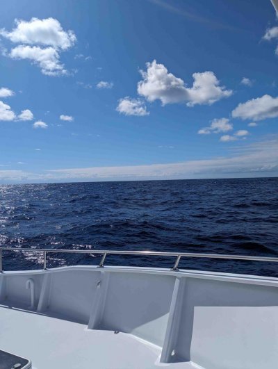
Currently 50 miles off the Oregon coast in mellow conditions. Below about the only picture of big blue I will need for the next two weeks as the scenery doesn't change a whole lot, and one of a local shop window in Westport. Imagine my disappointment when I found out it was just a tackle shop that also does whale watching tours.
I almost spit my drink out at the picture!
Last edited:
OP
OP
Delfin
Grand Vizier
- Joined
- Jan 20, 2010
- Messages
- 3,850
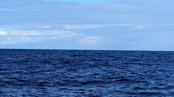
170 miles out of Hilo, so should arrive tomorrow. Much has changed since we sailed there years ago. Now, you can only anchor in one small area of Hilo Harbor that only has 12 ft of water at low low tide, and you need a permit for every place you anchor in the state. Other than the generation of massive amounts of paper, I'm not sure what the point is, but ok, it's your state.
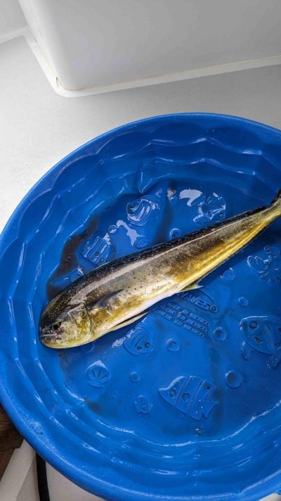
Rainy early this am, but weather passes quickly (sometimes) in the ocean so now it's just fine. Following 6 foot seas and maybe 8 knots apparent wind. Finally caught a Mahi Mahi, about 32 inches long. I like to use a kiddie wading pool for cleaning to contain the gore.
Rainy early this am, but weather passes quickly (sometimes) in the ocean so now it's just fine. Following 6 foot seas and maybe 8 knots apparent wind. Finally caught a Mahi Mahi, about 32 inches long. I like to use a kiddie wading pool for cleaning to contain the gore.
Attachments
Max Simmons
Guru
- Joined
- Oct 15, 2007
- Messages
- 822
- Vessel Make
- Ocean Alexander 38'
Thanks for letting us tag along. Perhaps I missed it, but where are you headed after HI?
OP
OP
Delfin
Grand Vizier
- Joined
- Jan 20, 2010
- Messages
- 3,850
After hanging in the Islands for a few weeks, we'll head back to the PNW, perhaps via the Queen Charlottes, but that will depend on swell direction. Sometimes you can go that far north on a return comfortably, sometimes not.Thanks for letting us tag along. Perhaps I missed it, but where are you headed after HI?
hoplite808
Member
- Joined
- Jun 2, 2023
- Messages
- 14
170 miles out of Hilo, so should arrive tomorrow. Much has changed since we sailed there years ago. Now, you can only anchor in one small area of Hilo Harbor that only has 12 ft of water at low low tide, and you need a permit for every place you anchor in the state. Other than the generation of massive amounts of paper, I'm not sure what the point is, but ok, it's your state.
Rainy early this am, but weather passes quickly (sometimes) in the ocean so now it's just fine. Following 6 foot seas and maybe 8 knots apparent wind. Finally caught a Mahi Mahi, about 32 inches long. I like to use a kiddie wading pool for cleaning to contain the gore.
Hawaii loves to complicate everything with absurd amounts of red tape. Be thankful the prop cage bill didn't pass during a few years ago legislative session. They wanted to make it illegal for any boat to enter state waters unless fitted with a prop cage to help prevent accidental marine life or human strikes with boat propellers. They also keep raising all the fees at the State Harbors claiming it is needed for maintenance costs but all the money collected has to be turned over to the State General fund and then the Harbors are given a shoe string budget to operate.
OP
OP
Delfin
Grand Vizier
- Joined
- Jan 20, 2010
- Messages
- 3,850
Lovely place, Hawaii, although running it like the DMV does detract a bit. Hadn't heard about the prop cage proposal. I guess we can anticipate that in a few years, you'll have to arrive in an electric boat to land.Hawaii loves to complicate everything with absurd amounts of red tape. Be thankful the prop cage bill didn't pass during a few years ago legislative session. They wanted to make it illegal for any boat to enter state waters unless fitted with a prop cage to help prevent accidental marine life or human strikes with boat propellers. They also keep raising all the fees at the State Harbors claiming it is needed for maintenance costs but all the money collected has to be turned over to the State General fund and then the Harbors are given a shoe string budget to operate.
OP
OP
Delfin
Grand Vizier
- Joined
- Jan 20, 2010
- Messages
- 3,850
I guess I don't know what that is, but it sounds like I should ..What is the fee for the Orma Use Permit?
hoplite808
Member
- Joined
- Jun 2, 2023
- Messages
- 14
Hawaii ORMA use permit is found here: https://dlnr.hawaii.gov/dobor/files/2020/09/App-ORMA.pdf
Also the visiting Vessel Form for the State: https://files.hawaii.gov/dlnr/dobor/forms/visitingvessel/visitingvessel_fillable.pdf
I don't know what the fees are.
Also the visiting Vessel Form for the State: https://files.hawaii.gov/dlnr/dobor/forms/visitingvessel/visitingvessel_fillable.pdf
I don't know what the fees are.
OP
OP
Delfin
Grand Vizier
- Joined
- Jan 20, 2010
- Messages
- 3,850
That's not the form visiting yachts are required to fill out. Boats fill out a 'Tempoary Moorage Application.'. I'll know what the fee is when we land a bit later.Hawaii ORMA use permit is found here: https://dlnr.hawaii.gov/dobor/files/2020/09/App-ORMA.pdf
Also the visiting Vessel Form for the State: https://files.hawaii.gov/dlnr/dobor/forms/visitingvessel/visitingvessel_fillable.pdf
I don't know what the fees are.
OP
OP
Delfin
Grand Vizier
- Joined
- Jan 20, 2010
- Messages
- 3,850
Similar threads
Latest posts
-

-

-

-
-
-

-
 48-volt house bank. Next Gen for boats?
- Latest: Mischief Managed
-
 Boat issues found after the survey and deal closed
- Latest: Turtle Blues
-
