Following Seas

The friendliest place on the web for anyone who enjoys boating.
If you have answers, please help by responding to the unanswered posts.

AKDoug

Guru
Joined
Feb 7, 2013
Messages
1,252
Location
USA
Vessel Name
Melanie Rose
Vessel Make
1999 Willard PH
I have had a little experience with my Willard 30 in following seas, but more like a fair sized swell with no wind driving it. How large a following sea have YOU been in and with how much wind driving it? I am looking for a clue for what I might be in for getting my boat from Whittier to Homer (Alaska) since the fall weather is one rolling system after another this year. The wave action would be wide open Gulf of Alaska open water for about 30 miles, almost directly on the stern or lightly port quartering. Thinking about it...
 
Following seas are one of the Willard's best points of "sailing"
Their canoe stern does not lift and slew like a transom stern at all. As a result the bow shows little willingness to bury as the stern splits and lifts rather than just lifts. I have never had a autopilot control problem in following seas 6' for hours, larger in inlets. Very welcome at night when one can't see what is coming.
 
I have had a little experience with my Willard 30 in following seas, but more like a fair sized swell with no wind driving it. How large a following sea have YOU been in and with how much wind driving it? I am looking for a clue for what I might be in for getting my boat from Whittier to Homer (Alaska) since the fall weather is one rolling system after another this year. The wave action would be wide open Gulf of Alaska open water for about 30 miles, almost directly on the stern or lightly port quartering. Thinking about it...

That would be a fun trip, and one I would like to do!

You're going have a bit more than 30 miles of open sea aren't you?

From Whittier you'll enter the Gulf Of Alaska at Cape Puget, then its almost exactly 90NM to Gore point on a bearing of 240 degrees. You'll have a little manuvering at the Chiswell Islands, and some more at the Pye islands.

The seas this time of year will be on your stern/port quarter(east winds), and could even be port beam(south east winds), possibly even port forward quarter(south winds).They won't be fully on your stern or starboard unless there's a winter storm system setting in.

If you're looking for a great place to anchor off prior to making that all day journey there's a great anchorage at the lower end of Bainbridge passage, and another one at Goat Harbor inside Puget Bay.
 
Last edited:
The first jump is from PWS by Elrington Island over to Resurrection Bay, that's the 30 miles of wide open water. The Fiords run around the rest of the way with copious numbers of bays to pull into along the way, no really long jumps without a bay to run into and I can take them one or two at a time. It is more North than you think from the Sound, almost a straight line from PWS to Resurrection and the point where you turn into Homer. Good protection up past Nuka Island, running with the tide I should make Port Chatham in a single day's run. Home free from Chatham :) Shrimp season is over the 15th, so I need to kill a couple of birds with one stone, shrimp and travel. Homer has the best services and cheapest lift. Seward has some issues...
 
Willy has been fine w 6 to 7' following seas moderately breaking.

I do have hydraulic steering and 45 degrees of rudder swing. And I've used full rudder many times but after a long time it seems silly to attempt to keep the boat on a straight course so I let her swing quite a bit and save some energy at the helm.

I used to say to pilots "it serves no purpose keeping the wings level flying in turbulence so relax a little and let her bob around some". Same applies to boats but as w AC one needs to know the limits of the vehicle so as to be safe at all times. Obviously one needs to get in a bit of trouble to know the limits but fortunately the Willard boat will take care of you probably well into the trouble zone. A square stern trawler light in the stern w small rudders may be another matter.
 
If you are hand steering in a nasty following sea, one of the best things you can have is a Brodie Knob (AKA suicide knob) on your wheel. It will really cut down on the workload.
 
Can you quantify how much wind was pushing the seas? I am used to finding things out the hard way, but then again I don't usually push my way out into iffy weather on purpose. I rode out a squall with maybe 30 knots of wind and 5-7 foot seas, on the bow. My only experience with following seas with wind is planed out and running at wave speed between the swells. Can't do that in the Willard :) I am just trying to get a good idea what it would be like "in case" I don't get a perfect weather pattern for the move. Freeze up is coming, the fall colors are everywhere, time to get things in place for the winter. I have about 35 degrees of rudder, when crossing the Gulf on the way up, the following seas gave the autopilot no issues and it never even got warm. There were a few "weird" issues, the key in the keyway for the rudder was undersized and walked out leaving me briefly rudderless. Fortunately the emergency tiller was aboard and fixing it was easy since the key fell into the bilge. Then coming into Seward the steering wheel came off in my hands. Turns out the shaft of the hydraulic steering is a different size than the hole in the steering wheel, so a brass bushing was installed to mate them. Would have been fine, except the threaded shaft on the steering unit was bypassed and the bushing was pinned with a hole drilled in the shaft. Thusly the wheel was held on by a roll pin on one side of the bushing (not all the way through it) and the nut I thought held on the wheel was decorative. Got out the vise grips to steer with just in case, pinned it back on with an ice pick, and docked with no issues. Drilled the hole all the way through the bushing and pinned both sides, to be properly repaired at a later date. Got to love adventures. Wouldn't have wanted either of them to happen single handing in heavy following seas...
 
it's all about steepness...not size....

Ask locals what size and period makes them uncomfortable in what will be about the only useful guide.

Then you have to see how your boat handles it.

Breaking is also not definitive. Larger sea waves (swells) will look like a crest but it's actually a wind wave on the swell that's foaming and not dangerous (to a point). Once the swells get big enough or in shallow enough water or against a current...then they want to crest and topple...usually that's storm seas/surf and not something any of us plan to be in....
 
I AM a local :) I am specifically asking "Willard" owners what they have run in, and what they consider their limits for comfort to be. I am trying to avoid being surprised by it when I drive out into it. I have run the Gulf many times in smaller boats and I have been doing this in a 24' Bayliner since 1985. The outflow currents from several bays have a lot of influence several miles offshore along my 30 mile stretch of open water. I am looking for specific information, not the generalities that I am well aware of. Thanks...
 
Wind velocity?

Done 40 knots several times in open water like the straits of Georgia. All the above I've also done in my previous boat also ... Albin 25.

Very little ocean experience. Mostly places like Dixon Entrance that is quite open to the ocean but not really in it.

This is just my trawler experience. Had a friend also w an Albin 25 that would'nt go out in a 25 knot forecast ... or worse. I soon found that one could go in considerably worse conditions safely but frequently uncomfortably.
 
Cannot offer any advice at all, since we don't have such goings on in the river here. But did want to say that I am vacillating between envying you and being glad that it is you rather than me that is going to be doing that. :)

John
 
That is helpful. I have a forecast for 15 to 25 knots, with seas running 6-12 feet. Open ocean usually means big swells with light chop on top as the winds diminish, so I will hope for big swells (I love that) with minimal wind on top. Looking good for next week, making plans :) 40 knots sounds pretty snotty...
 
The first jump is from PWS by Elrington Island over to Resurrection Bay, that's the 30 miles of wide open water. The Fiords run around the rest of the way with copious numbers of bays to pull into along the way, no really long jumps without a bay to run into and I can take them one or two at a time. It is more North than you think from the Sound, almost a straight line from PWS to Resurrection and the point where you turn into Homer. Good protection up past Nuka Island, running with the tide I should make Port Chatham in a single day's run. Home free from Chatham :) Shrimp season is over the 15th, so I need to kill a couple of birds with one stone, shrimp and travel. Homer has the best services and cheapest lift. Seward has some issues...

Hey Doug

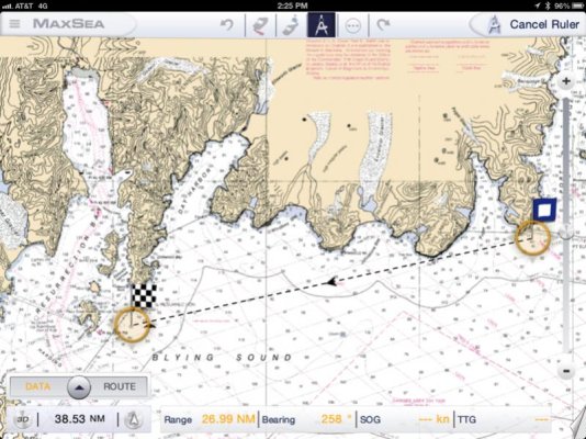
I know it's your home turf, but its mine as well. I've attached screen shots from my charting application.

There is no northward travel in your proposed route, until your past Gore Point


image-2893636310.jpg


image-522827598.jpg


image-2635266775.jpg


image-1437416326.jpg

Best of luck on your trip. Be prepared for beam seas.
 
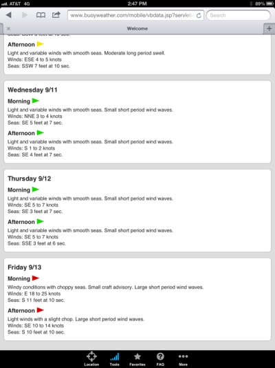
Here's the sea state report. This is based on a location between Seward and Prince William Sound


image-2907574993.jpg


image-324733640.jpg
 
You are correct, I always forget how East/West the Fiords run. I should have quartering following seas about to Resurrection and then pretty much beam seas all the rest of the way around the Fiords. The line of travel is almost straight along the coast but the angle of the waves change along the Fiords. I was planning on taking the bays one or two at a time, and using the islands to break it up a bit. Seas are moderating in PWS on Tuesday and in the Gulf around Wednesday, a nice four or five day window... Weather is rolling out there this week.
 
Doug you'll want to "tack" like a sail boat and avoid beam seas at right angles. A course of about 20 to 30 degrees off seems to work best. Having the time to run a zig zag course for extended periods is helpful. If you're forced to run parallel to a beam sea hang on tight and spread your legs really wide. And for peace of mind recall the two tons of ballast in the keel.
 
Although I don't have a Willard 30, my hull is very similar and I'd expect the Willard would handle the same or even better.

If you are lucky enough to get following seas, you have the perfect boat to handle it. I've been pushed along by 6-8 feet of steep breaking surf without even a hint of broaching, although I keep the boat directly perpendicular to the swell in these conditions.

A big beam sea will be uncomfortable, but not dangerous unless very steep. As Eric said, a wide stance is needed, and make sure everything is secured. Take some seasick medicine if you are so inclined. As suggested, a bit of experimenting will soon show you the best angle of attack in differing conditions.

Psneeld has mad an important point about the steepness of the waves. That is really what its all about. The wave interval number in a marine forecast is equally important to wind speed or wave height. I would much rather be out in a 12 foot swell at a 20 second interval than a 6 foot waves at 5 second intervals.

As a rough rule of thumb, beware when the wave interval is less than the wave height.
 
Many long range boats have round fan take style sterns to reduce the effect of following seas so the most of the wave force passes around and under the boat. Most commercial have what I call the trawler stern which is sort of a cross of a canoe rounded and fan tail which is the full beam for working but quickly narrows. The Eagle has a ugly rounded stern similar to a trawler stern with a full wrap around swim deck.
 
I don't see psneeld's posts as he is on my ignore list. That is both good and bad. I avoid his flack and acid but I also miss what he says and he has much to say very much worth listening to ... this being a good example;

"Psneeld has mad an important point about the steepness of the waves. That is really what its all about. The wave interval number in a marine forecast is equally important to wind speed or wave height. I would much rather be out in a 12 foot swell at a 20 second interval than a 6 foot waves at 5 second intervals."

No psneeld isn't mad of course but the fact that ALL waves and sea conditions are different needs to be taken into account. Extremely confused 5' seas near Guard Is just out of Ketchikan was the worst water I have experienced with Willy. We were lifted up and thrown to stbd into basically a hole. Initially there was no water to resist so we fell further. And that wasn't far in 5' seas but when we hit water the shape of the water seemed to fit the bottom/side of the hull so it was like a hammer hitting the anvil. I heard a sharp sound that sounded like something was damaged but never found anything.
The 5' seas at this point were converging from 3 different directions and we were in a tide rip to boot.
No public weather report of any accuracy would have even hinted of the nasty that occurred at that point. Nor could I have said we battled monstrous seas to communicate the nasty that was there.
We often talk of 6' seas, 15' seas ect but it's just a guess about the height. I was once in 18' seas (or were they more) on an OB boat and described them as as big as a 2 story house. I wrote a story post on that experience here on TF and don't recall the yardstick I used but in any event it was just a guess from the past. But there are so many variables that going or not going based on the height prediction of waves and the velocity of wind is basically folly.
There was another place near Ketchikan that was a tidal convergence and all boaters know about it. Almost half the time the seas there are much worse than a mile away. Camano Point. I got trashed there so many times I eventually started favoring the middle of Clarence Strait to avoid the spot.
So when one goes forth in one's boat one never knows what's out there but in defense of what Doug and probably all the rest of us do we make use of most of the information and experience available.

I found the account of my experience in Dixon Entrance mentioned above.

"I designed a boat in college. I was really impressed by the Bertram deep V boats and set out to design a boat that would ride softly and also be efficient. I succeeded. I built a 28' x 9' *prototype in the school shop at Masset BC. It was ultralight disp, plywood and powered by a 55hp Johnson OB. I came down Dixon Entrance (giving Rose Spit a wide berth) went across Hecate Strait to Prince Rupert. I left the boat there for 2 months. When I got back I cleaned the bottom (right next to the sewer outlet I later discovered) and made ready for the trip south. In the morning I changed my mind (it happens) and decided to go north to SE Alaska instead. But the wind was blowing * * ...HARD. The bay was covered w fine white spray about 15' high ripped from the surface and blown into the air. There was a cafe on one of the cannery docks where all the fishermen were. After whining about the weather for a couple of hours they told me it just blows in the harbor. Thought they were joking w me but decided no one would con a man into going out to possible death and I knew I could make it across the bay in the 50 knot wind so off I went. The boat was basically a hull w an engine, a 45gal fuel tank and a small cuddy cabin to keep my gear out of the weather and to sleep. Helm was outside. Across the bay I entered the 5 or 6 mile long Metlakatla Passage. The fishermen seemed to be right as the wind was down to 25 - 30. Followed the markers out the end of the channel and out into Chatham Sound (not to be confused w Chatham Strait). The seas were kinda scary but the boat seemed to be handling it well. The wind was SSW so I was quartering a port stern sea. The boat was doing so well I decided to keep going as I could always drop the old Danforth next to the islands to the west or in Brundige Inlet on Dundas Is. It was still fairly early in the long northern summer day so I thought I was going to spend the night at the docks in Ketchikan quite a number of hours away. Chatham Sound is a long run and the seas built steadily and slowly as I made my way to Green Island Light. The big seas just continued to roll under me and the boat handled better from the fuel burn-loss so things seemed to continue about the same. I passed Green Is and was amazed at the white froth leaping from the rocks into the air on the rocky beach. I decided to head for Brundige Inlet but as I make my way the seas seem to calm quite a bit. I knew part of it was the lee of Dundas Is and possibly Green Is so it looked really doable. This is where my judgement went south. The run across Dixon Entrance is at least 20 miles so I was going to be at the whim of Dixion Entrance and basically the limitless fetch of Hecate Strait for at least an hour and a half. As I left Dundas Is astern the wind picked up. The seas started to break. I turned around and started a run to Brundage Inlet On Dundas Is. *Now I was taking it on the stbd bow and it was MUCH worse. Progress was drastically reduced and the boat trip changed from high adventure for a young man to a scary thing I just wanted to get over with. It was far from over. The seas were so big I didn't see the horizon very often. The seas were a bit fwd of my port stern quarter and I became worried the breakers would just flip me over. I decided I needed to keep a close eye on the crests so I'd be ready to quickly swing to port and directly into the wave I'd be able to ride the wave safely. But the wind had returned to about 50 knots and while trying a coupla of practice runs the bow of the extremely light boat wanted to blow over backwards. Very scary but I hadn't shipped any water yet. The seas responded to the wind and began to berak seriously. The waves broke and rushed fwd so quickly I had no chance to turn the boat fast enough to take the seas head on. Summer or not it was getting quite dark and the water looked black. I saw only one other boat that day. It was a "Tahiti Ketch". A 45' sail boat that could be considered a very early passagemaker. It was very beamy and full at both ends. I'm sure it had tons of ballast. I know about how much water she drew as I was on top of a wave (most of the time I could only see her masts) at the same time she was going over another wave and I saw her Keel at the end of her rudder. I'd say she drew about 8'. These waves seemed like mountians of water.*About the size of a 2 story house. Lots of the waves were breaking now and it was only a matter of time until it happened right on my port side. When it did I thought I was a gonner. The port rail rose up to the breaker until I had my left foot on the floor and my right on the inside of the stbd side. More weight on the right. Just before the boat went over something totally unexpected happened. The side of the hull was 45 degrees to vertical and presented a surface for the boat to slide sideways, sort of planing, as the hull rushed down the face of the wave almost to the trough and out of the worst danger. This happened nermerous times in the next 45 min. I was scared bugless each time and was just desprate to get to the spot where I could turn to stbd and put those breakers on my stern. The breakers eased, the turn came and I was high w relief headed straight for Mary Island Light. But I wasn't out of trouble yet. The ebb tide was rushing right past Mary Is and I was rushing toward Mary Is thinking how wonderful it was going to be to be that close to land. As I approached I could see I was headed for more trouble but being abeam to the seas was not an option I was ready to take. For the long run past Mary Is I labored up one sea after another and as I reached the crest I needed to chop the throttle to an idle just at the right moment for the plunge down the face of the wave only to work my way up the backside of the next wave. My timing didn't fail and I finally made it past Mary Island. Things calmed down quickly after a short while running up Rivalagigado Channel nearing Ketchikan. It continued to rain off and on w sudden sun breaks and rainbows. I used a motorcycle helmet w a face shield for a rain hat when needed and I think I smiled all the rest of the way to Ketchikan. As I went to sleep I overheard two fishermen talking "Look at that boat. I'll bet that's the one they were talking about on 16. Came across Dixon in the gale." I think I heard the word crazy as their voices faded away but I learned my lesson and without paying w my life."
 
Last edited:
The rebound off the steep shores make a real "mixmaster" effect. There are few beaches to absorb the wave energy so the swells rebound off the rock faces and come back almost as large as they hit, but at a different angle. Kind of like the grill marks on a steak :) They you mix in the outflow currents from the bays and it gets real interesting. Very nice post, thanks for sharing.
 
Hey doug, I have done this trip before but I came up from Seldovia. The only bad part was around the Chugach islands. Some pretty big tides in the area. Try and go for a slack tide if you can. Especially between the mainland and Elizabeth island. I helped a friend bring a 36' Bayliner from Seldovia around this time of the year.
Good luck my friend.

SD
 
I’ve had my 36 in 16-18 footers,running straight into it,and on the steam back was directly on the stern,they weren’t breakers,but fairly steep and stacked up,and never once did I feel unsafe
 

Latest posts

Back
Top Bottom